Rodeo night lights from space
Night Light of Rodeo (California) from space (United States) Src. Average luminocity for 10x10km area is 44.224% and for 50x50km: 32.0478%.
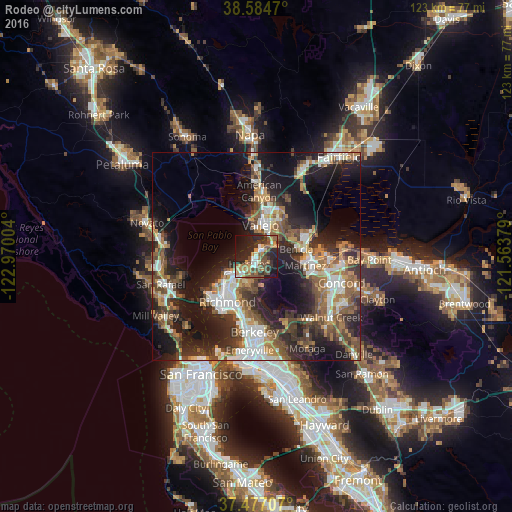
Analysis of Rodeo night lights 2016
Square area 10x10 km:
 4.55%
4.55%90-99
5.03%80-89
3.9%70-79
8.6%60-69
6.66%50-59
8.6%40-49
11.04%30-39
8.44%20-29
21.75%10-19
17.86%0-9
3.57%Square area 50x50 km:
5.14%90-99
5.09%80-89
2.04%70-79
4.23%60-69
4.86%50-59
5.82%40-49
6.35%30-39
5.7%20-29
10.99%10-19
18.38%0-9
31.41%Clear (daylight) street map image can be seen on geolist.org.
Map coordinates:
38° 35' 4.9" North, 122° 58' 12.1" West
38° 1' 58.7" North, 122° 16' 0.9" West
37° 28' 37.5" North, 121° 33' 49.6" West
Some cities around Rodeo sort by population:
• Vallejo
8 km =5 mi,  6°
6°
• Martinez
11.7 km =7.3 mi,  97°
97°
• San Pablo
10.5 km =6.5 mi,  221°
221°
• Benicia
9.7 km =6 mi,  79°
79°
• Hercules
2.6 km =1.6 mi,  227°
227°
• Pinole
4.2 km =2.6 mi, 221°
• El Sobrante
6.7 km =4.2 mi,  201°
201°
• Tara Hills
6.2 km =3.9 mi, 224°
5388467 (p: 8,679)
Sources (retrieved 2019-11-25):
» Earth at Night: Flat Maps 2012, 2016