Kutztown night lights from space
Night Light of Kutztown (Pennsylvania) from space (United States) Src. Average luminocity for 10x10km area is 19.3997% and for 50x50km: 23.26%.
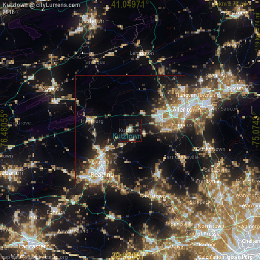
Analysis of Kutztown night lights 2016
Square area 10x10 km:
 1.87%
1.87%90-99
2.38%80-89
3.57%70-79
1.7%60-69
1.19%50-59
2.55%40-49
3.06%30-39
0.68%20-29
2.55%10-19
28.57%0-9
51.87%Square area 50x50 km:
3.5%90-99
3.62%80-89
3.18%70-79
3.2%60-69
3.42%50-59
3.24%40-49
3.1%30-39
3.85%20-29
5.63%10-19
13.16%0-9
54.1%Clear (daylight) street map image can be seen on geolist.org.
Map coordinates:
41° 2' 59" North, 76° 28' 50" West
40° 31' 2.4" North, 75° 46' 38.7" West
39° 58' 50.4" North, 75° 4' 27.5" West
Some cities around Kutztown sort by population:
• Allentown
26.3 km =16.3 mi,  67°
67°
• Reading
23.8 km =14.8 mi,  212°
212°
• Emmaus
23.8 km =14.8 mi,  84°
84°
• Wyomissing
26.2 km =16.3 mi,  217°
217°
• Blandon
12.5 km =7.8 mi,  227°
227°
• Ancient Oaks
16.2 km =10.1 mi, 78°
• Red Lion
14.2 km =8.8 mi,  106°
106°
• Wescosville
19.7 km =12.2 mi, 73°
5196621 (p: 5,028)
Sources (retrieved 2019-11-25):
» Earth at Night: Flat Maps 2012, 2016