Mount Carmel night lights from space
Night Light of Mount Carmel (Pennsylvania) from space (United States) Src. Average luminocity for 10x10km area is 9.8435% and for 50x50km: 8.1344%.
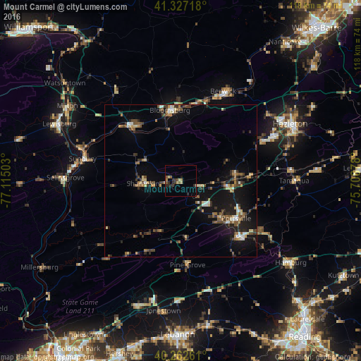
Analysis of Mount Carmel night lights 2016
Square area 10x10 km:
 0%
0%90-99
0%80-89
2.72%70-79
0%60-69
2.38%50-59
1.7%40-49
0.85%30-39
3.06%20-29
4.42%10-19
0.51%0-9
84.35%Square area 50x50 km:
0.46%90-99
0.76%80-89
1.13%70-79
0.8%60-69
0.9%50-59
1.44%40-49
1.34%30-39
1.76%20-29
2.05%10-19
7.17%0-9
82.18%Clear (daylight) street map image can be seen on geolist.org.
Map coordinates:
41° 19' 37.8" North, 77° 6' 54.1" West
40° 47' 49.3" North, 76° 24' 42.8" West
40° 15' 45.4" North, 75° 42' 31.6" West
Some cities around Mount Carmel sort by population:
• Bloomsburg
23.3 km =14.5 mi,  351°
351°
• Pottsville
22 km =13.7 mi,  124°
124°
• Berwick
32.3 km =20.1 mi,  27°
27°
• Sunbury
33 km =20.5 mi,  282°
282°
• Shamokin
12.4 km =7.7 mi,  265°
265°
• Tamaqua
37.2 km =23.1 mi,  89°
89°
• Selinsgrove
37.9 km =23.5 mi, 270°
• Schuylkill Haven
27.5 km =17.1 mi,  132°
132°
5202114 (p: 5,728)
Sources (retrieved 2019-11-25):
» Earth at Night: Flat Maps 2012, 2016