Berwick night lights from space
Night Light of Berwick (Pennsylvania) from space (United States) Src. Average luminocity for 10x10km area is 18.0918% and for 50x50km: 8.0863%.
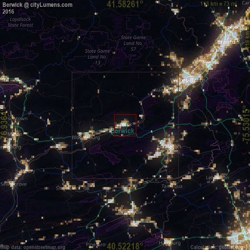
Analysis of Berwick night lights 2016
Square area 10x10 km:
 2.21%
2.21%90-99
2.55%80-89
1.7%70-79
4.42%60-69
0.51%50-59
1.53%40-49
4.42%30-39
0%20-29
2.72%10-19
11.05%0-9
68.88%Square area 50x50 km:
0.82%90-99
0.95%80-89
0.82%70-79
1.01%60-69
0.92%50-59
1.01%40-49
1.26%30-39
1.87%20-29
2.52%10-19
5.97%0-9
82.85%Clear (daylight) street map image can be seen on geolist.org.
Map coordinates:
41° 34' 57.4" North, 76° 56' 11" West
41° 3' 16.3" North, 76° 13' 59.8" West
40° 31' 19.8" North, 75° 31' 48.5" West
Some cities around Berwick sort by population:
• Wilkes-Barre
36.3 km =22.6 mi,  54°
54°
• Hazleton
24.2 km =15 mi,  116°
116°
• Bloomsburg
19.4 km =12.1 mi,  253°
253°
• Mountain Top
32.4 km =20.1 mi,  66°
66°
• Nanticoke
25.4 km =15.8 mi, 48°
• Tamaqua
36.2 km =22.5 mi,  142°
142°
• Plymouth
31.8 km =19.8 mi, 49°
• Mount Carmel
32.3 km =20.1 mi,  207°
207°
5180119 (p: 10,223)
Sources (retrieved 2019-11-25):
» Earth at Night: Flat Maps 2012, 2016