Sunset Hills night lights from space
Night Light of Sunset Hills (Missouri) from space (United States) Src. Average luminocity for 10x10km area is 84.1851% and for 50x50km: 58.9512%.
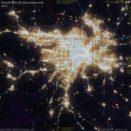
Analysis of Sunset Hills night lights 2016
Square area 10x10 km:
 17.37%
90-99
22.08%80-89
19.81%70-79
24.84%60-69
13.96%50-59
1.62%40-49
0.32%30-39
0%20-29
0%10-19
0%0-9
0%Square area 50x50 km:
16.26%90-99
12.88%80-89
7.8%70-79
10.5%60-69
8.26%50-59
6.43%40-49
4.08%30-39
5.26%20-29
5.9%10-19
9.78%0-9
12.86%Clear (daylight) street map image can be seen on geolist.org.
Map coordinates:
39° 5' 12.5" North, 91° 6' 37.7" West
38° 32' 20.2" North, 90° 24' 26.4" West
37° 59' 12.7" North, 89° 42' 15.2" West
Some cities around Sunset Hills sort by population:
• Kirkwood
4.9 km =3 mi,  0°
0°
• Webster Groves
7.4 km =4.6 mi,  36°
36°
• Affton
6.6 km =4.1 mi,  78°
78°
• Concord
4.6 km =2.9 mi,  110°
110°
• Crestwood
3 km =1.9 mi,  47°
47°
• Des Peres
7.2 km =4.5 mi,  342°
342°
• Sappington
2.4 km =1.5 mi,  95°
95°
• Glendale
6.9 km =4.3 mi,  22°
22°
4410836 (p: 8,539)
Sources (retrieved 2019-11-25):
» Earth at Night: Flat Maps 2012, 2016