Lock Haven night lights from space
Night Light of Lock Haven (Pennsylvania) from space (United States) Src. Average luminocity for 10x10km area is 17.849% and for 50x50km: 1.6253%.
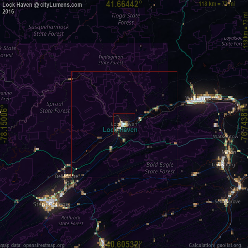
Analysis of Lock Haven night lights 2016
Square area 10x10 km:
 2.92%
2.92%90-99
2.92%80-89
1.62%70-79
0.32%60-69
3.25%50-59
2.27%40-49
2.44%30-39
1.79%20-29
2.76%10-19
14.77%0-9
64.94%Square area 50x50 km:
0.14%90-99
0.18%80-89
0.22%70-79
0.14%60-69
0.25%50-59
0.24%40-49
0.3%30-39
0.28%20-29
0.3%10-19
0.76%0-9
97.18%Clear (daylight) street map image can be seen on geolist.org.
Map coordinates:
41° 39' 51.9" North, 78° 9' 0.2" West
41° 8' 13.2" North, 77° 26' 48.9" West
40° 36' 19.2" North, 76° 44' 37.7" West
Some cities around Lock Haven sort by population:
• State College
51.6 km =32.1 mi,  222°
222°
• Williamsport
39.1 km =24.3 mi,  72°
72°
• Park Forest Village
53.9 km =33.5 mi,  227°
227°
• Lewistown
60.7 km =37.7 mi,  189°
189°
• Milton
52.1 km =32.4 mi,  105°
105°
• South Williamsport
38.9 km =24.2 mi, 74°
• Bellefonte
37.3 km =23.2 mi, 228°
• Lewisburg
50.9 km =31.6 mi, 112°
5198635 (p: 9,604)
Sources (retrieved 2019-11-25):
» Earth at Night: Flat Maps 2012, 2016