Springboro night lights from space
Night Light of Springboro (Ohio) from space (United States) Src. Average luminocity for 10x10km area is 62.1981% and for 50x50km: 39.9804%.
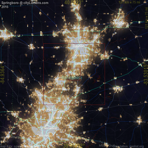
Analysis of Springboro night lights 2016
Square area 10x10 km:
 7.47%
7.47%90-99
9.74%80-89
9.74%70-79
12.99%60-69
13.64%50-59
13.15%40-49
10.39%30-39
12.82%20-29
9.58%10-19
0.49%0-9
0%Square area 50x50 km:
6.61%90-99
7.61%80-89
5.34%70-79
7.24%60-69
7.1%50-59
6.77%40-49
5.66%30-39
6%20-29
6.87%10-19
7.51%0-9
33.3%Clear (daylight) street map image can be seen on geolist.org.
Map coordinates:
40° 5' 32.3" North, 84° 56' 11" West
39° 33' 8.2" North, 84° 13' 59.8" West
39° 0' 28.9" North, 83° 31' 48.5" West
Some cities around Springboro sort by population:
• Middletown
14.7 km =9.1 mi,  253°
253°
• Centerville
10.6 km =6.6 mi,  36°
36°
• Lebanon
13.3 km =8.3 mi,  168°
168°
• Miamisburg
11.1 km =6.9 mi,  335°
335°
• West Carrollton City
13.4 km =8.3 mi,  353°
353°
• Franklin
6.1 km =3.8 mi,  276°
276°
• Germantown
14.3 km =8.9 mi,  305°
305°
• Carlisle
8.2 km =5.1 mi,  293°
293°
4525304 (p: 18,213)
Sources (retrieved 2019-11-25):
» Earth at Night: Flat Maps 2012, 2016