West Carrollton City night lights from space
Night Light of West Carrollton City (Ohio) from space (United States) Src. Average luminocity for 10x10km area is 74.7987% and for 50x50km: 41.6363%.
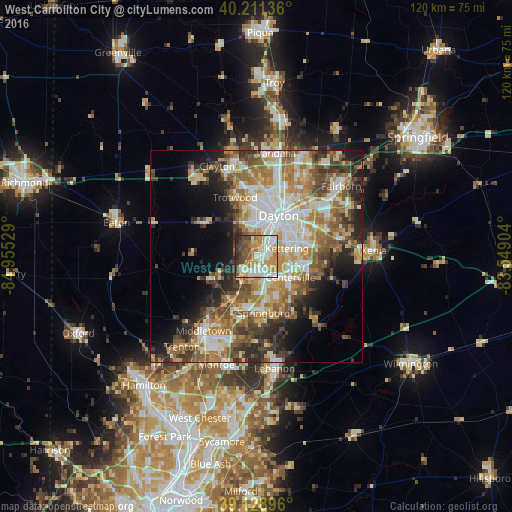
Analysis of West Carrollton City night lights 2016
Square area 10x10 km:
 18.18%
90-99
18.99%80-89
11.53%70-79
16.4%60-69
8.12%50-59
5.36%40-49
12.18%30-39
5.52%20-29
3.73%10-19
0%0-9
0%Square area 50x50 km:
7.46%90-99
8.31%80-89
5.7%70-79
6.5%60-69
7.31%50-59
6.43%40-49
6.14%30-39
5.87%20-29
6.92%10-19
8.55%0-9
30.81%Clear (daylight) street map image can be seen on geolist.org.
Map coordinates:
40° 12' 40.9" North, 84° 57' 19" West
39° 40' 20.2" North, 84° 15' 7.8" West
39° 7' 44.3" North, 83° 32' 56.5" West
Some cities around West Carrollton City sort by population:
• Dayton
10.9 km =6.8 mi,  28°
28°
• Kettering
7.4 km =4.6 mi,  74°
74°
• Centerville
9.3 km =5.8 mi,  121°
121°
• Miamisburg
4.4 km =2.7 mi,  222°
222°
• Oakwood
8.9 km =5.5 mi,  48°
48°
• Moraine
4.7 km =2.9 mi,  36°
36°
• Germantown
11.3 km =7 mi,  242°
242°
• Carlisle
11.6 km =7.2 mi,  210°
210°
4527963 (p: 13,297)
Sources (retrieved 2019-11-25):
» Earth at Night: Flat Maps 2012, 2016