Centerville night lights from space
Night Light of Centerville (Ohio) from space (United States) Src. Average luminocity for 10x10km area is 76.1364% and for 50x50km: 40.5835%.
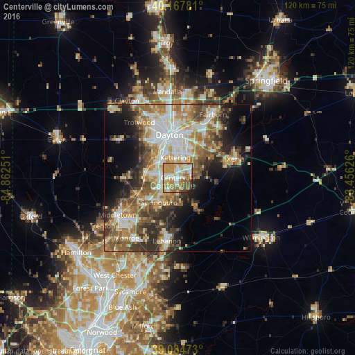

Analysis of Centerville night lights 2016
Square area 10x10 km:
 14.45%
90-99
17.05%80-89
8.93%70-79
28.41%60-69
13.15%50-59
9.42%40-49
4.38%30-39
1.79%20-29
2.11%10-19
0.32%0-9
0%Square area 50x50 km:
7.14%90-99
8.02%80-89
5.4%70-79
6.42%60-69
6.96%50-59
6.57%40-49
5.75%30-39
5.71%20-29
7.31%10-19
8.97%0-9
31.75%Clear (daylight) street map image can be seen on geolist.org.
Map coordinates:
40° 10' 4.1" North, 84° 51' 45" West
39° 37' 42.2" North, 84° 9' 33.8" West
39° 5' 5" North, 83° 27' 22.5" West
Some cities around Centerville sort by population:
• Kettering
6.8 km =4.2 mi,  353°
353°
• Beavercreek
12.2 km =7.6 mi,  42°
42°
• Miamisburg
11 km =6.8 mi,  278°
278°
• Springboro
10.6 km =6.6 mi,  216°
216°
• West Carrollton City
9.3 km =5.8 mi,  301°
301°
• Oakwood
10.9 km =6.8 mi, 353°
• Bellbrook
7.6 km =4.7 mi,  83°
83°
• Moraine
10.1 km =6.3 mi,  329°
329°
4508204 (p: 23,882)
Sources (retrieved 2019-11-25):
» Earth at Night: Flat Maps 2012, 2016