Spring Grove night lights from space
Night Light of Spring Grove (Illinois) from space (United States) Src. Average luminocity for 10x10km area is 31.2524% and for 50x50km: 29.9134%.
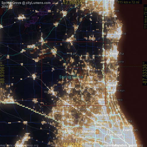
Analysis of Spring Grove night lights 2016
Square area 10x10 km:
 0.95%
0.95%90-99
0.32%80-89
2.54%70-79
5.08%60-69
6.19%50-59
5.56%40-49
10.32%30-39
5.56%20-29
17.14%10-19
45.24%0-9
1.11%Square area 50x50 km:
2.1%90-99
2.61%80-89
3.4%70-79
4.21%60-69
6.28%50-59
7.63%40-49
8.04%30-39
6.75%20-29
8.39%10-19
14.13%0-9
36.46%Clear (daylight) street map image can be seen on geolist.org.
Map coordinates:
42° 57' 37.3" North, 88° 56' 22.6" West
42° 26' 37.1" North, 88° 14' 11.3" West
41° 55' 21.4" North, 87° 32' 0.1" West
Some cities around Spring Grove sort by population:
• Round Lake Beach
14.4 km =8.9 mi,  123°
123°
• McHenry
12.5 km =7.8 mi,  191°
191°
• Antioch
12.1 km =7.5 mi,  72°
72°
• Fox Lake
6.8 km =4.2 mi,  140°
140°
• Lake Villa
13.7 km =8.5 mi,  102°
102°
• Johnsburg
7.1 km =4.4 mi,  183°
183°
• Twin Lakes
9.8 km =6.1 mi,  354°
354°
• Lakemoor
13.2 km =8.2 mi,  166°
166°
4912248 (p: 5,711)
Sources (retrieved 2019-11-25):
» Earth at Night: Flat Maps 2012, 2016