Fox Lake night lights from space
Night Light of Fox Lake (Illinois) from space (United States) Src. Average luminocity for 10x10km area is 47.3317% and for 50x50km: 40.422%.
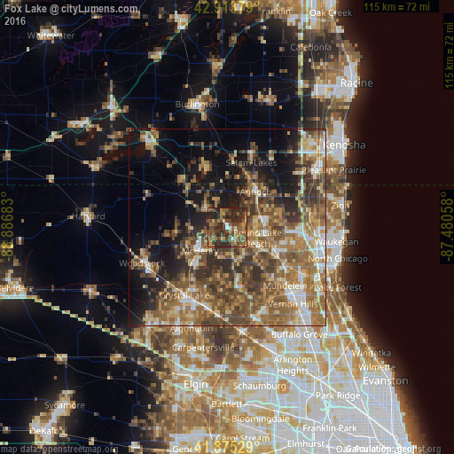
Analysis of Fox Lake night lights 2016
Square area 10x10 km:
 1.27%
1.27%90-99
1.9%80-89
5.08%70-79
8.41%60-69
8.89%50-59
15.56%40-49
17.3%30-39
15.08%20-29
25.08%10-19
1.43%0-9
0%Square area 50x50 km:
3.76%90-99
4.62%80-89
4.99%70-79
5.95%60-69
9.79%50-59
10.66%40-49
9.7%30-39
7.27%20-29
8.3%10-19
12.58%0-9
22.39%Clear (daylight) street map image can be seen on geolist.org.
Map coordinates:
42° 54' 49.6" North, 88° 53' 12.6" West
42° 23' 48.1" North, 88° 11' 1.3" West
41° 52' 31" North, 87° 28' 50.1" West
Some cities around Fox Lake sort by population:
• Round Lake Beach
8.2 km =5.1 mi,  109°
109°
• McHenry
9.8 km =6.1 mi,  224°
224°
• Round Lake
8.8 km =5.5 mi,  123°
123°
• Lake Villa
9.3 km =5.8 mi,  75°
75°
• Round Lake Park
9.8 km =6.1 mi, 116°
• Johnsburg
5.1 km =3.2 mi,  248°
248°
• Lakemoor
7.7 km =4.8 mi,  189°
189°
• Spring Grove
6.8 km =4.2 mi,  320°
320°
4892950 (p: 10,518)
Sources (retrieved 2019-11-25):
» Earth at Night: Flat Maps 2012, 2016