Twin Lakes night lights from space
Night Light of Twin Lakes (Wisconsin) from space (United States) Src. Average luminocity for 10x10km area is 19.5651% and for 50x50km: 22.8737%.
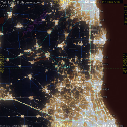
Analysis of Twin Lakes night lights 2016
Square area 10x10 km:
 0%
0%90-99
0%80-89
2.86%70-79
3.02%60-69
3.81%50-59
2.86%40-49
2.38%30-39
4.76%20-29
6.67%10-19
31.9%0-9
41.75%Square area 50x50 km:
1.24%90-99
1.87%80-89
2.71%70-79
3.09%60-69
4.47%50-59
5.44%40-49
5.46%30-39
4.95%20-29
7.09%10-19
15%0-9
48.67%Clear (daylight) street map image can be seen on geolist.org.
Map coordinates:
43° 2' 49.6" North, 88° 57' 4.6" West
42° 31' 52.1" North, 88° 14' 53.3" West
42° 0' 39" North, 87° 32' 42.1" West
Some cities around Twin Lakes sort by population:
• Antioch
13.9 km =8.6 mi,  115°
115°
• Salem
11.5 km =7.1 mi,  76°
76°
• Burlington
16.5 km =10.3 mi,  352°
352°
• Fox Lake
15.9 km =9.9 mi,  160°
160°
• Lake Villa
19.1 km =11.9 mi,  131°
131°
• Lake Geneva
16.6 km =10.3 mi,  293°
293°
• Johnsburg
16.8 km =10.4 mi,  178°
178°
• Spring Grove
9.8 km =6.1 mi,  174°
174°
5276542 (p: 6,094)
Sources (retrieved 2019-11-25):
» Earth at Night: Flat Maps 2012, 2016