Lakemoor night lights from space
Night Light of Lakemoor (Illinois) from space (United States) Src. Average luminocity for 10x10km area is 45.6152% and for 50x50km: 45.4326%.
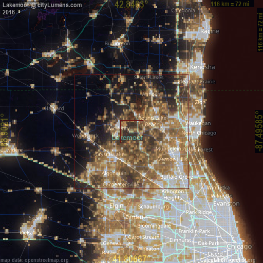
Analysis of Lakemoor night lights 2016
Square area 10x10 km:
 0.3%
0.3%90-99
1.67%80-89
6.21%70-79
7.27%60-69
9.55%50-59
9.85%40-49
17.42%30-39
16.21%20-29
31.52%10-19
0%0-9
0%Square area 50x50 km:
4.65%90-99
6.02%80-89
5.8%70-79
6.68%60-69
10.77%50-59
12.03%40-49
10.47%30-39
8%20-29
8.48%10-19
11.24%0-9
15.87%Clear (daylight) street map image can be seen on geolist.org.
Map coordinates:
42° 50' 46.7" North, 88° 54' 7.6" West
42° 19' 43.1" North, 88° 11' 56.3" West
41° 48' 24" North, 87° 29' 45.1" West
Some cities around Lakemoor sort by population:
• Round Lake Beach
10.1 km =6.3 mi,  61°
61°
• McHenry
5.6 km =3.5 mi,  275°
275°
• Round Lake
9.1 km =5.7 mi,  72°
72°
• Wauconda
9.2 km =5.7 mi,  147°
147°
• Fox Lake
7.7 km =4.8 mi,  9°
9°
• Island Lake
5.9 km =3.7 mi,  174°
174°
• Round Lake Park
10.5 km =6.5 mi, 72°
• Johnsburg
6.7 km =4.2 mi,  328°
328°
4899213 (p: 6,015)
Sources (retrieved 2019-11-25):
» Earth at Night: Flat Maps 2012, 2016