Southold night lights from space
Night Light of Southold (New York) from space (United States) Src. Average luminocity for 10x10km area is 7.0617% and for 50x50km: 6.9119%.
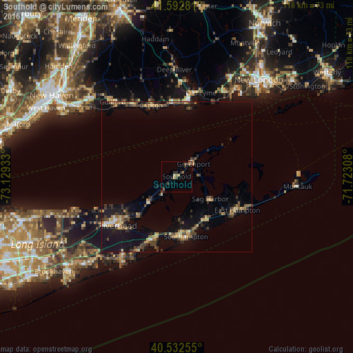
Analysis of Southold night lights 2016
Square area 10x10 km:
 0%
0%90-99
0.81%80-89
0.65%70-79
0.81%60-69
1.62%50-59
1.95%40-49
1.3%30-39
0.97%20-29
2.92%10-19
0.65%0-9
88.31%Square area 50x50 km:
0.18%90-99
0.37%80-89
1.14%70-79
0.82%60-69
0.85%50-59
1.2%40-49
1.58%30-39
1.13%20-29
1.9%10-19
6.03%0-9
84.82%Clear (daylight) street map image can be seen on geolist.org.
Map coordinates:
41° 35' 34.1" North, 73° 7' 45.6" West
41° 3' 53.4" North, 72° 25' 34.3" West
40° 31' 57.2" North, 71° 43' 23.1" West
Some cities around Southold sort by population:
• Guilford
32.8 km =20.4 mi,  319°
319°
• Madison
27.9 km =17.3 mi,  328°
328°
• Hampton Bays
23.1 km =14.4 mi,  199°
199°
• Riverhead
25.7 km =16 mi,  230°
230°
• Old Saybrook
25.6 km =15.9 mi,  9°
9°
• Wading River
37.2 km =23.1 mi,  249°
249°
• Springs
23 km =14.3 mi,  103°
103°
• Calverton
31.9 km =19.8 mi,  236°
236°
5139054 (p: 5,748)
Sources (retrieved 2019-11-25):
» Earth at Night: Flat Maps 2012, 2016