Lockhart night lights from space
Night Light of Lockhart (Florida) from space (United States) Src. Average luminocity for 10x10km area is 95.517% and for 50x50km: 69.6002%.
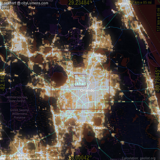
Analysis of Lockhart night lights 2016
Square area 10x10 km:
 34.09%
90-99
49.43%80-89
12.5%70-79
3.98%60-69
0%50-59
0%40-49
0%30-39
0%20-29
0%10-19
0%0-9
0%Square area 50x50 km:
21.06%90-99
20.06%80-89
8.84%70-79
9.8%60-69
9.85%50-59
3.7%40-49
3.55%30-39
4.76%20-29
6.47%10-19
6.01%0-9
5.91%Clear (daylight) street map image can be seen on geolist.org.
Map coordinates:
29° 14' 5.4" North, 82° 8' 44.5" West
28° 37' 10" North, 81° 26' 33.3" West
28° 0' 1.5" North, 80° 44' 22" West
Some cities around Lockhart sort by population:
• Pine Hills
6.9 km =4.3 mi,  188°
188°
• Altamonte Springs
8.8 km =5.5 mi,  58°
58°
• Wekiwa Springs
9 km =5.6 mi,  10°
10°
• Maitland
7.8 km =4.8 mi,  83°
83°
• Forest City
5.3 km =3.3 mi,  359°
359°
• Fairview Shores
5.7 km =3.5 mi,  123°
123°
• Orlovista
9.2 km =5.7 mi, 190°
• South Apopka
8.1 km =5 mi,  305°
305°
4162539 (p: 13,060)
Sources (retrieved 2019-11-25):
» Earth at Night: Flat Maps 2012, 2016