Somerton night lights from space
Night Light of Somerton (Arizona) from space (United States) Src. Average luminocity for 10x10km area is 17.0035% and for 50x50km: 14.0154%.
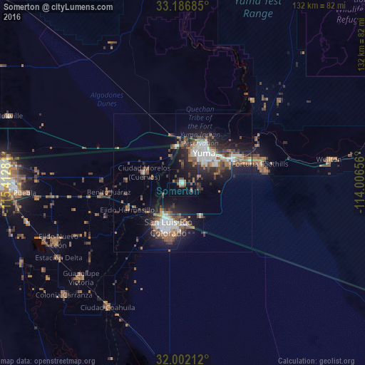
Analysis of Somerton night lights 2016
Square area 10x10 km:
 1.22%
1.22%90-99
1.4%80-89
0.17%70-79
0.17%60-69
5.42%50-59
2.97%40-49
2.45%30-39
3.5%20-29
2.97%10-19
21.68%0-9
58.04%Square area 50x50 km:
2.39%90-99
2.23%80-89
0.58%70-79
0.51%60-69
2.72%50-59
2.99%40-49
2.21%30-39
2.48%20-29
3.93%10-19
9.76%0-9
70.21%Clear (daylight) street map image can be seen on geolist.org.
Map coordinates:
33° 11' 12.7" North, 115° 24' 46.1" West
32° 35' 47.2" North, 114° 42' 34.8" West
32° 0' 7.6" North, 114° 0' 23.6" West
Some cities around Somerton sort by population:
• San Luis Río Colorado, MX
16.7 km =10.4 mi,  200°
200°
• Yuma
16.4 km =10.2 mi,  29°
29°
• San Luis
13.9 km =8.6 mi,  209°
209°
• Fortuna Foothills
28.7 km =17.8 mi,  76°
76°
• Guadalupe Victoria, MX
50.4 km =31.3 mi,  227°
227°
• Ciudad Coahuila (Kilómetro Cincuenta y Siete), MX
52.4 km =32.6 mi, 211°
• Tecolots, MX
25.9 km =16.1 mi,  262°
262°
• Hermosillo, MX
22.1 km =13.7 mi,  244°
244°
5315062 (p: 15,048)
Sources (retrieved 2019-11-25):
» Earth at Night: Flat Maps 2012, 2016