Hermosillo night lights from space
Night Light of Hermosillo (Baja California) from space (Mexico) Src. Average luminocity for 10x10km area is 6.5165% and for 50x50km: 9.1439%.
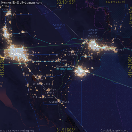
Analysis of Hermosillo night lights 2016
Square area 10x10 km:
 0%
0%90-99
0%80-89
0%70-79
0%60-69
3.66%50-59
2.01%40-49
1.1%30-39
1.83%20-29
0.73%10-19
0.73%0-9
89.93%Square area 50x50 km:
1.09%90-99
1.07%80-89
0.22%70-79
0.34%60-69
2.24%50-59
2.44%40-49
1.86%30-39
1.73%20-29
2.24%10-19
5.62%0-9
81.15%Clear (daylight) street map image can be seen on geolist.org.
Map coordinates:
33° 6' 7" North, 115° 37' 33.3" West
32° 30' 39.5" North, 114° 55' 22" West
31° 54' 57.9" North, 114° 13' 10.8" West
Some cities around Hermosillo sort by population:
• San Luis Río Colorado
15.4 km =9.6 mi,  113°
113°
• San Luis, US
13.5 km =8.4 mi,  101°
101°
• Guadalupe Victoria
30 km =18.6 mi,  214°
214°
• Somerton, US
22.1 km =13.7 mi,  64°
64°
• Estación Coahuila
36.1 km =22.4 mi,  191°
191°
• Ciudad Coahuila (Kilómetro Cincuenta y Siete)
35.9 km =22.3 mi, 192°
• Tecolots
8.4 km =5.2 mi,  317°
317°
• Delta
31 km =19.3 mi,  235°
235°
4011587 (p: 5,101)
Sources (retrieved 2019-11-25):
» Earth at Night: Flat Maps 2012, 2016