Tecolots night lights from space
Night Light of Tecolots (Baja California) from space (Mexico) Src. Average luminocity for 10x10km area is 9.1591% and for 50x50km: 7.6129%.
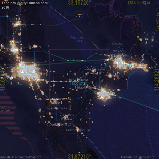
Analysis of Tecolots night lights 2016
Square area 10x10 km:
 0%
0%90-99
0%80-89
0%70-79
0%60-69
2.27%50-59
4.72%40-49
3.15%30-39
3.67%20-29
2.97%10-19
0.7%0-9
82.52%Square area 50x50 km:
0.9%90-99
0.86%80-89
0.09%70-79
0.2%60-69
1.94%50-59
2.18%40-49
1.83%30-39
1.46%20-29
1.53%10-19
3.36%0-9
85.64%Clear (daylight) street map image can be seen on geolist.org.
Map coordinates:
33° 9' 26.2" North, 115° 41' 11.3" West
32° 34' 0" North, 114° 58' 60" West
31° 58' 19.7" North, 114° 16' 48.8" West
Some cities around Tecolots sort by population:
• San Luis Río Colorado
23.3 km =14.5 mi,  121°
121°
• Yuma, US
38 km =23.6 mi,  62°
62°
• San Luis, US
20.8 km =12.9 mi, 115°
• Guadalupe Victoria
32.9 km =20.4 mi,  200°
200°
• Puebla
34.7 km =21.6 mi,  269°
269°
• Somerton, US
25.9 km =16.1 mi,  82°
82°
• Delta
30.9 km =19.2 mi,  220°
220°
• Hermosillo
8.4 km =5.2 mi,  137°
137°
3982215 (p: 5,259)
Sources (retrieved 2019-11-25):
» Earth at Night: Flat Maps 2012, 2016