Somers night lights from space
Night Light of Somers (Wisconsin) from space (United States) Src. Average luminocity for 10x10km area is 40.7924% and for 50x50km: 23.5384%.
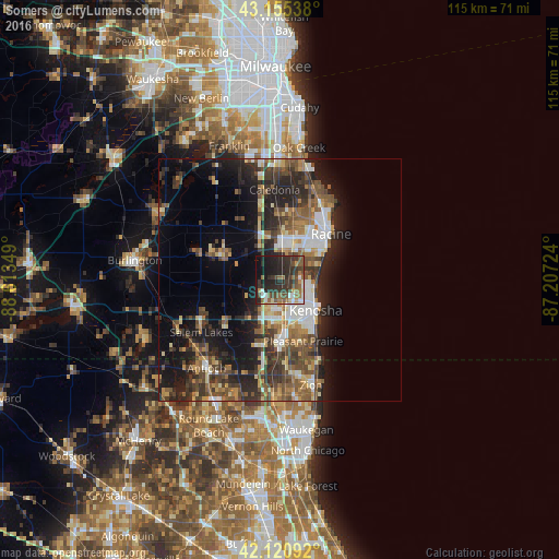
Analysis of Somers night lights 2016
Square area 10x10 km:
 5%
5%90-99
5%80-89
2.73%70-79
2.88%60-69
6.52%50-59
10.3%40-49
8.03%30-39
13.03%20-29
23.18%10-19
19.09%0-9
4.24%Square area 50x50 km:
2.92%90-99
3.11%80-89
2.36%70-79
2.67%60-69
3.41%50-59
4.72%40-49
5.02%30-39
5.19%20-29
8.74%10-19
11.97%0-9
49.88%Clear (daylight) street map image can be seen on geolist.org.
Map coordinates:
43° 9' 19.4" North, 88° 36' 48.6" West
42° 38' 25.1" North, 87° 54' 37.3" West
42° 7' 15.3" North, 87° 12' 26.1" West
Some cities around Somers sort by population:
• Kenosha
9.6 km =6 mi,  130°
130°
• Racine
14.1 km =8.8 mi,  47°
47°
• Mount Pleasant
7.8 km =4.8 mi,  35°
35°
• Caledonia
18.7 km =11.6 mi,  356°
356°
• Pleasant Prairie
9.9 km =6.2 mi,  191°
191°
• Salem
19 km =11.8 mi,  239°
239°
• Sturtevant
6.6 km =4.1 mi,  11°
11°
• Winthrop Harbor
19.3 km =12 mi,  158°
158°
5273614 (p: 9,454)
Sources (retrieved 2019-11-25):
» Earth at Night: Flat Maps 2012, 2016