Siler City night lights from space
Night Light of Siler City (North Carolina) from space (United States) Src. Average luminocity for 10x10km area is 24.8689% and for 50x50km: 4.2745%.
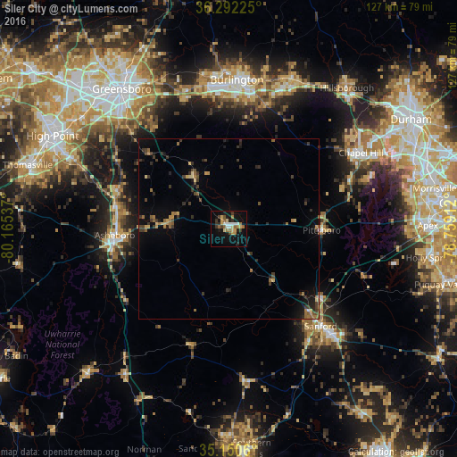
Analysis of Siler City night lights 2016
Square area 10x10 km:
 2.45%
2.45%90-99
3.67%80-89
4.37%70-79
3.15%60-69
3.67%50-59
3.5%40-49
1.75%30-39
4.2%20-29
3.32%10-19
23.6%0-9
46.33%Square area 50x50 km:
0.13%90-99
0.17%80-89
0.62%70-79
0.46%60-69
0.89%50-59
0.55%40-49
0.56%30-39
1.4%20-29
0.85%10-19
2.8%0-9
91.57%Clear (daylight) street map image can be seen on geolist.org.
Map coordinates:
36° 17' 32.1" North, 80° 9' 55.3" West
35° 43' 24.5" North, 79° 27' 44.1" West
35° 9' 2.2" North, 78° 45' 32.8" West
Some cities around Siler City sort by population:
• Chapel Hill
42.3 km =26.3 mi,  60°
60°
• Burlington
41.4 km =25.7 mi,  3°
3°
• Sanford
37.2 km =23.1 mi,  136°
136°
• Asheboro
31.8 km =19.8 mi,  266°
266°
• Carrboro
40.6 km =25.2 mi, 59°
• Graham
38.8 km =24.1 mi,  8°
8°
• Elon
42.4 km =26.3 mi,  354°
354°
• Gibsonville
43.1 km =26.8 mi, 350°
4491651 (p: 8,396)
Sources (retrieved 2019-11-25):
» Earth at Night: Flat Maps 2012, 2016