Sanford night lights from space
Night Light of Sanford (North Carolina) from space (United States) Src. Average luminocity for 10x10km area is 61.8498% and for 50x50km: 9.9537%.
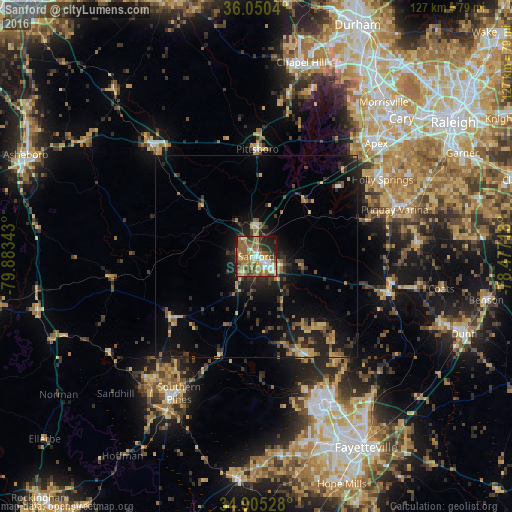

Analysis of Sanford night lights 2016
Square area 10x10 km:
 8.97%
8.97%90-99
8.61%80-89
10.26%70-79
11.17%60-69
18.86%50-59
11.54%40-49
8.61%30-39
5.31%20-29
11.72%10-19
4.95%0-9
0%Square area 50x50 km:
0.57%90-99
0.49%80-89
1.43%70-79
1.54%60-69
1.76%50-59
1.47%40-49
1.42%30-39
2.48%20-29
3.49%10-19
7.83%0-9
77.51%Clear (daylight) street map image can be seen on geolist.org.
Map coordinates:
36° 3' 1.4" North, 79° 53' 0.3" West
35° 28' 47.6" North, 79° 10' 49.1" West
34° 54' 19" North, 78° 28' 37.8" West
Some cities around Sanford sort by population:
• Apex
41 km =25.5 mi,  46°
46°
• Holly Springs
36.7 km =22.8 mi,  58°
58°
• Fort Bragg
41.1 km =25.5 mi,  157°
157°
• Fuquay-Varina
36.3 km =22.6 mi,  71°
71°
• Pinehurst
41.1 km =25.5 mi,  219°
219°
• Southern Pines
39.1 km =24.3 mi,  209°
209°
• Spring Lake
39.5 km =24.5 mi,  151°
151°
• Siler City
37.2 km =23.1 mi,  316°
316°
4490329 (p: 29,144)
Sources (retrieved 2019-11-25):
» Earth at Night: Flat Maps 2012, 2016