Shady Hollow night lights from space
Night Light of Shady Hollow (Texas) from space (United States) Src. Average luminocity for 10x10km area is 48.8182% and for 50x50km: 34.575%.
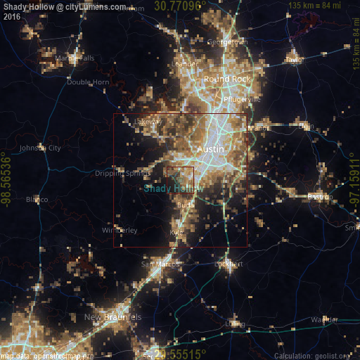
Analysis of Shady Hollow night lights 2016
Square area 10x10 km:
 3.5%
3.5%90-99
3.32%80-89
6.64%70-79
11.36%60-69
12.06%50-59
13.29%40-49
12.24%30-39
6.47%20-29
13.99%10-19
14.86%0-9
2.27%Square area 50x50 km:
5.37%90-99
5.16%80-89
4.84%70-79
5.06%60-69
6.1%50-59
7.67%40-49
6.62%30-39
4.59%20-29
6.18%10-19
10.07%0-9
38.35%Clear (daylight) street map image can be seen on geolist.org.
Map coordinates:
30° 46' 15.5" North, 98° 33' 55.3" West
30° 9' 53.7" North, 97° 51' 44" West
29° 33' 18.5" North, 97° 9' 32.8" West
Some cities around Shady Hollow sort by population:
• Austin
16.1 km =10 mi,  45°
45°
• San Marcos
32.2 km =20 mi,  193°
193°
• Kyle
19.6 km =12.2 mi,  184°
184°
• Jollyville
32 km =19.9 mi,  15°
15°
• Lakeway
24.8 km =15.4 mi,  332°
332°
• Buda
9.1 km =5.7 mi,  166°
166°
• Hornsby Bend
28.3 km =17.6 mi,  71°
71°
• Bee Cave
17.8 km =11.1 mi, 333°
4728052 (p: 5,004)
Sources (retrieved 2019-11-25):
» Earth at Night: Flat Maps 2012, 2016