Lakeway night lights from space
Night Light of Lakeway (Texas) from space (United States) Src. Average luminocity for 10x10km area is 45.4249% and for 50x50km: 30.6819%.
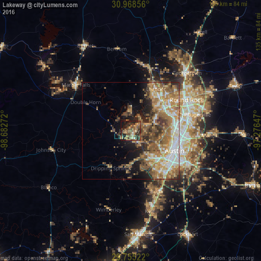
Analysis of Lakeway night lights 2016
Square area 10x10 km:
 1.1%
1.1%90-99
1.65%80-89
9.16%70-79
6.59%60-69
9.16%50-59
12.82%40-49
16.12%30-39
8.61%20-29
18.86%10-19
15.57%0-9
0.37%Square area 50x50 km:
4.41%90-99
4.76%80-89
4.34%70-79
4.96%60-69
6.51%50-59
7.05%40-49
4.87%30-39
3.86%20-29
4.95%10-19
6.99%0-9
47.31%Clear (daylight) street map image can be seen on geolist.org.
Map coordinates:
30° 58' 6.8" North, 98° 40' 57.8" West
30° 21' 49.6" North, 97° 58' 46.5" West
29° 45' 18.8" North, 97° 16' 35.3" West
Some cities around Lakeway sort by population:
• Austin
25.1 km =15.6 mi,  115°
115°
• Cedar Park
21.9 km =13.6 mi,  44°
44°
• Leander
26.8 km =16.7 mi,  26°
26°
• Jollyville
21.5 km =13.4 mi,  65°
65°
• Anderson Mill
19.5 km =12.1 mi,  58°
58°
• Lago Vista
10.8 km =6.7 mi,  355°
355°
• Bee Cave
7 km =4.3 mi,  151°
151°
• Shady Hollow
24.8 km =15.4 mi, 152°
4705041 (p: 14,217)
Sources (retrieved 2019-11-25):
» Earth at Night: Flat Maps 2012, 2016