Hornsby Bend night lights from space
Night Light of Hornsby Bend (Texas) from space (United States) Src. Average luminocity for 10x10km area is 35.1853% and for 50x50km: 36.5947%.
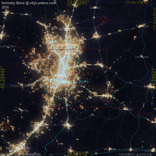
Analysis of Hornsby Bend night lights 2016
Square area 10x10 km:
 1.05%
1.05%90-99
1.05%80-89
5.94%70-79
6.47%60-69
3.32%50-59
12.94%40-49
11.01%30-39
8.57%20-29
8.57%10-19
20.63%0-9
20.45%Square area 50x50 km:
6.78%90-99
6.9%80-89
4.98%70-79
5.56%60-69
6.34%50-59
6.25%40-49
4.61%30-39
4.42%20-29
5.09%10-19
9.53%0-9
39.53%Clear (daylight) street map image can be seen on geolist.org.
Map coordinates:
30° 51' 10.6" North, 98° 17' 11.3" West
30° 14' 50.7" North, 97° 34' 60" West
29° 38' 17.4" North, 96° 52' 48.8" West
Some cities around Hornsby Bend sort by population:
• Austin
15.5 km =9.6 mi,  278°
278°
• Pflugerville
21.6 km =13.4 mi,  350°
350°
• Jollyville
28.5 km =17.7 mi,  319°
319°
• Wells Branch
23.9 km =14.9 mi,  337°
337°
• Elgin
23.4 km =14.5 mi,  60°
60°
• Manor
10.7 km =6.6 mi,  13°
13°
• Camp Swift
28.7 km =17.8 mi,  102°
102°
• Shady Hollow
28.3 km =17.6 mi,  251°
251°
4698809 (p: 6,791)
Sources (retrieved 2019-11-25):
» Earth at Night: Flat Maps 2012, 2016