Jollyville night lights from space
Night Light of Jollyville (Texas) from space (United States) Src. Average luminocity for 10x10km area is 74.0458% and for 50x50km: 47.6618%.
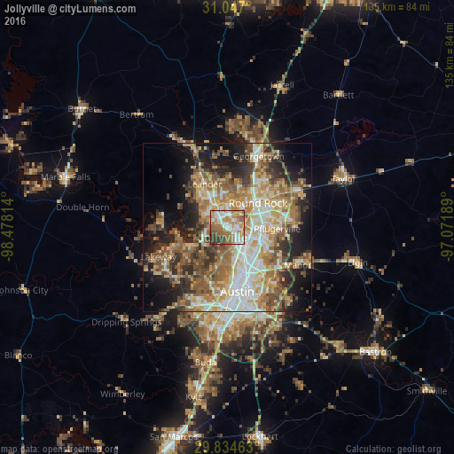
Analysis of Jollyville night lights 2016
Square area 10x10 km:
 16.12%
90-99
16.85%80-89
6.23%70-79
14.29%60-69
20.51%50-59
14.47%40-49
4.4%30-39
6.96%20-29
0.18%10-19
0%0-9
0%Square area 50x50 km:
7.62%90-99
8.11%80-89
6.99%70-79
8.18%60-69
9.27%50-59
8.88%40-49
6.8%30-39
5.6%20-29
8.66%10-19
12.59%0-9
17.3%Clear (daylight) street map image can be seen on geolist.org.
Map coordinates:
31° 2' 49.2" North, 98° 28' 41.3" West
30° 26' 33.7" North, 97° 46' 30" West
29° 50' 4.7" North, 97° 4' 18.8" West
Some cities around Jollyville sort by population:
• Austin
19.8 km =12.3 mi,  171°
171°
• Round Rock
11.7 km =7.3 mi,  51°
51°
• Cedar Park
8.2 km =5.1 mi,  328°
328°
• Pflugerville
14.9 km =9.3 mi,  91°
91°
• Leander
16.9 km =10.5 mi, 333°
• Brushy Creek
8.6 km =5.3 mi,  23°
23°
• Wells Branch
9.2 km =5.7 mi, 87°
• Anderson Mill
3.3 km =2.1 mi,  294°
294°
4701458 (p: 16,151)
Sources (retrieved 2019-11-25):
» Earth at Night: Flat Maps 2012, 2016