Seymour night lights from space
Night Light of Seymour (Tennessee) from space (United States) Src. Average luminocity for 10x10km area is 29.6429% and for 50x50km: 33.392%.
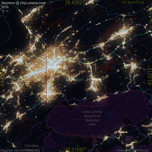
Analysis of Seymour night lights 2016
Square area 10x10 km:
 1.47%
1.47%90-99
2.56%80-89
0.73%70-79
2.56%60-69
7.51%50-59
10.81%40-49
6.59%30-39
8.42%20-29
9.16%10-19
21.98%0-9
28.21%Square area 50x50 km:
4.84%90-99
4.9%80-89
5.12%70-79
4.28%60-69
5.74%50-59
5.74%40-49
5.07%30-39
6.32%20-29
7.49%10-19
16.08%0-9
34.43%Clear (daylight) street map image can be seen on geolist.org.
Map coordinates:
36° 27' 29.6" North, 84° 25' 39.9" West
35° 53' 26.3" North, 83° 43' 28.6" West
35° 19' 8.3" North, 83° 1' 17.4" West
Some cities around Seymour sort by population:
• Knoxville
19.3 km =12 mi,  293°
293°
• Maryville
26.7 km =16.6 mi,  236°
236°
• Farragut
38.6 km =24 mi,  268°
268°
• Sevierville
14.9 km =9.3 mi,  99°
99°
• Alcoa
25.1 km =15.6 mi, 243°
• Jefferson City
33.2 km =20.6 mi,  39°
39°
• Pigeon Forge
19.1 km =11.9 mi,  126°
126°
• Eagleton Village
21.5 km =13.4 mi, 240°
4656630 (p: 10,919)
Sources (retrieved 2019-11-25):
» Earth at Night: Flat Maps 2012, 2016