Farragut night lights from space
Night Light of Farragut (Tennessee) from space (United States) Src. Average luminocity for 10x10km area is 72.4762% and for 50x50km: 43.5439%.

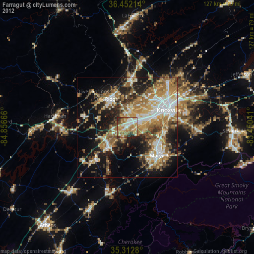
Analysis of Farragut night lights 2016
Square area 10x10 km:
 14.47%
90-99
13.92%80-89
11.9%70-79
10.99%60-69
20.88%50-59
13.92%40-49
5.86%30-39
5.68%20-29
2.38%10-19
0%0-9
0%Square area 50x50 km:
6.56%90-99
6.57%80-89
6.87%70-79
6.78%60-69
8.55%50-59
7.01%40-49
6.12%30-39
7.37%20-29
9.6%10-19
14.77%0-9
19.81%Clear (daylight) street map image can be seen on geolist.org.
Map coordinates:
36° 27' 7.7" North, 84° 51' 24" West
35° 53' 4.3" North, 84° 9' 12.7" West
35° 18' 46.1" North, 83° 27' 1.5" West
Some cities around Farragut sort by population:
• Knoxville
22.6 km =14 mi,  68°
68°
• Oak Ridge
17.5 km =10.9 mi,  323°
323°
• Maryville
21.8 km =13.5 mi,  130°
130°
• Alcoa
19.3 km =12 mi,  123°
123°
• Lenoir City
13.4 km =8.3 mi,  223°
223°
• Tellico Village
24.2 km =15 mi,  202°
202°
• Loudon
23.4 km =14.5 mi, 223°
• Eagleton Village
22.3 km =13.9 mi, 116°
4621846 (p: 21,919)
Sources (retrieved 2019-11-25):
» Earth at Night: Flat Maps 2012, 2016