Eagleton Village night lights from space
Night Light of Eagleton Village (Tennessee) from space (United States) Src. Average luminocity for 10x10km area is 58.764% and for 50x50km: 31.9648%.
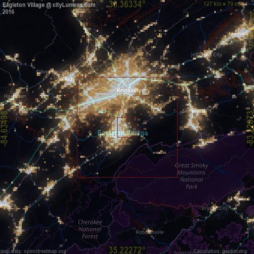
Analysis of Eagleton Village night lights 2016
Square area 10x10 km:
 13.29%
90-99
13.11%80-89
5.94%70-79
9.79%60-69
9.79%50-59
9.44%40-49
2.8%30-39
7.34%20-29
12.06%10-19
14.86%0-9
1.57%Square area 50x50 km:
5.41%90-99
5.28%80-89
4.75%70-79
4.88%60-69
6.32%50-59
5.19%40-49
4.38%30-39
5.27%20-29
5.4%10-19
8.27%0-9
44.85%Clear (daylight) street map image can be seen on geolist.org.
Map coordinates:
36° 21' 48" North, 84° 38' 5.9" West
35° 47' 42.3" North, 83° 55' 54.7" West
35° 13' 21.8" North, 83° 13' 43.4" West
Some cities around Eagleton Village sort by population:
• Knoxville
18.4 km =11.4 mi,  3°
3°
• Maryville
5.5 km =3.4 mi,  219°
219°
• Farragut
22.3 km =13.9 mi,  296°
296°
• Seymour
21.5 km =13.4 mi,  60°
60°
• Alcoa
3.8 km =2.4 mi,  260°
260°
• Lenoir City
29.2 km =18.1 mi,  270°
270°
• Pigeon Forge
34.1 km =21.2 mi,  91°
91°
• Tellico Village
31.7 km =19.7 mi,  246°
246°
4619893 (p: 5,052)
Sources (retrieved 2019-11-25):
» Earth at Night: Flat Maps 2012, 2016