Sevierville night lights from space
Night Light of Sevierville (Tennessee) from space (United States) Src. Average luminocity for 10x10km area is 51.9066% and for 50x50km: 16.8397%.
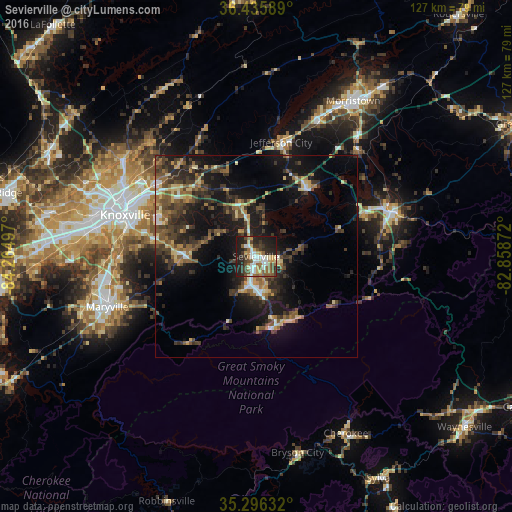
Analysis of Sevierville night lights 2016
Square area 10x10 km:
 8.42%
8.42%90-99
9.89%80-89
7.33%70-79
5.49%60-69
7.51%50-59
9.52%40-49
7.33%30-39
9.52%20-29
19.05%10-19
15.93%0-9
0%Square area 50x50 km:
1%90-99
1.33%80-89
2.61%70-79
1.63%60-69
2.18%50-59
3.56%40-49
3.42%30-39
5.01%20-29
6.07%10-19
13.64%0-9
59.56%Clear (daylight) street map image can be seen on geolist.org.
Map coordinates:
36° 26' 9.2" North, 84° 15' 53.9" West
35° 52' 5.3" North, 83° 33' 42.6" West
35° 17' 46.8" North, 82° 51' 31.4" West
Some cities around Sevierville sort by population:
• Knoxville
33.9 km =21.1 mi,  287°
287°
• Maryville
38.9 km =24.2 mi,  251°
251°
• Seymour
14.9 km =9.3 mi,  279°
279°
• Alcoa
38.2 km =23.7 mi,  256°
256°
• Jefferson City
28.9 km =18 mi,  12°
12°
• Newport
35.4 km =22 mi,  71°
71°
• Pigeon Forge
8.9 km =5.5 mi,  175°
175°
• Eagleton Village
34.3 km =21.3 mi, 256°
4656585 (p: 16,490)
Sources (retrieved 2019-11-25):
» Earth at Night: Flat Maps 2012, 2016