Alcoa night lights from space
Night Light of Alcoa (Tennessee) from space (United States) Src. Average luminocity for 10x10km area is 79.0664% and for 50x50km: 33.4446%.
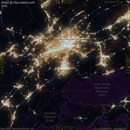
Analysis of Alcoa night lights 2016
Square area 10x10 km:
 20.8%
20.8%90-99
23.95%80-89
10.66%70-79
11.36%60-69
11.71%50-59
13.29%40-49
2.1%30-39
4.2%20-29
1.92%10-19
0%0-9
0%Square area 50x50 km:
5.51%90-99
5.37%80-89
4.91%70-79
5.07%60-69
6.52%50-59
5.72%40-49
4.86%30-39
5.74%20-29
6.08%10-19
8.5%0-9
41.73%Clear (daylight) street map image can be seen on geolist.org.
Map coordinates:
36° 21' 28.2" North, 84° 40' 36.9" West
35° 47' 22.3" North, 83° 58' 25.6" West
35° 13' 1.7" North, 83° 16' 14.4" West
Some cities around Alcoa sort by population:
• Knoxville
19.6 km =12.2 mi,  14°
14°
• Maryville
3.7 km =2.3 mi,  175°
175°
• Farragut
19.3 km =12 mi,  303°
303°
• Seymour
25.1 km =15.6 mi,  63°
63°
• Lenoir City
25.5 km =15.8 mi,  271°
271°
• Tellico Village
28 km =17.4 mi,  245°
245°
• Loudon
33.1 km =20.6 mi,  259°
259°
• Eagleton Village
3.8 km =2.4 mi,  80°
80°
4602181 (p: 9,316)
Sources (retrieved 2019-11-25):
» Earth at Night: Flat Maps 2012, 2016