Newport night lights from space
Night Light of Newport (Tennessee) from space (United States) Src. Average luminocity for 10x10km area is 44.8736% and for 50x50km: 8.4831%.
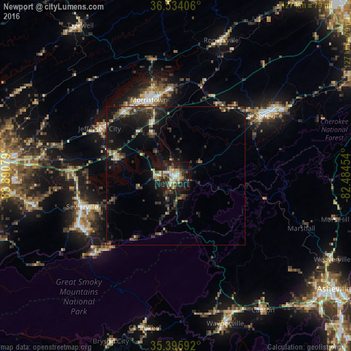
Analysis of Newport night lights 2016
Square area 10x10 km:
 7.88%
7.88%90-99
5.68%80-89
8.24%70-79
6.04%60-69
3.66%50-59
5.49%40-49
7.14%30-39
11.54%20-29
17.58%10-19
23.08%0-9
3.66%Square area 50x50 km:
0.57%90-99
0.56%80-89
1.13%70-79
0.84%60-69
0.77%50-59
1.03%40-49
1.67%30-39
2.98%20-29
3.1%10-19
8.33%0-9
79.02%Clear (daylight) street map image can be seen on geolist.org.
Map coordinates:
36° 32' 2.6" North, 83° 53' 26.8" West
35° 58' 1.3" North, 83° 11' 15.6" West
35° 23' 45.3" North, 82° 29' 4.3" West
Some cities around Newport sort by population:
• Morristown
29.1 km =18.1 mi,  340°
340°
• Sevierville
35.4 km =22 mi,  251°
251°
• Greeneville
38.8 km =24.1 mi,  55°
55°
• Seymour
49.1 km =30.5 mi,  260°
260°
• Waynesville
56.1 km =34.9 mi,  161°
161°
• Jefferson City
32.4 km =20.1 mi,  302°
302°
• Woodfin
66 km =41 mi,  124°
124°
• Pigeon Forge
38.5 km =23.9 mi,  238°
238°
4645532 (p: 6,834)
Sources (retrieved 2019-11-25):
» Earth at Night: Flat Maps 2012, 2016