Sequim night lights from space
Night Light of Sequim (Washington) from space (United States) Src. Average luminocity for 10x10km area is 9.2842% and for 50x50km: 1.2765%.
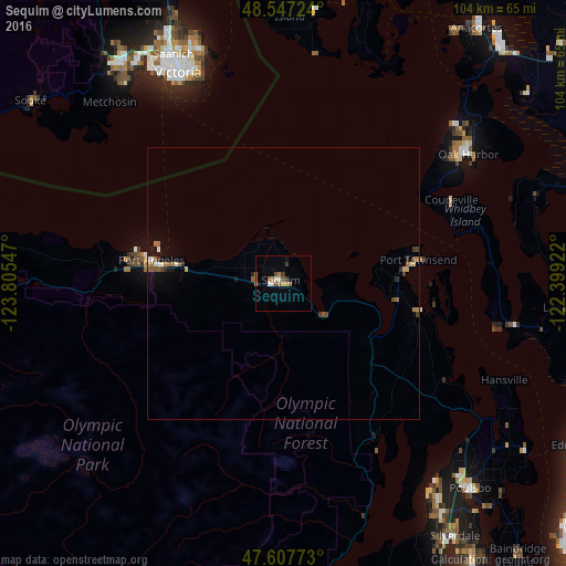
Analysis of Sequim night lights 2016
Square area 10x10 km:
 0.6%
0.6%90-99
1.79%80-89
0%70-79
1.49%60-69
2.38%50-59
1.79%40-49
1.19%30-39
1.79%20-29
0%10-19
1.19%0-9
87.8%Square area 50x50 km:
0.12%90-99
0.13%80-89
0.08%70-79
0.17%60-69
0.31%50-59
0.28%40-49
0.17%30-39
0.18%20-29
0.14%10-19
0.52%0-9
97.9%Clear (daylight) street map image can be seen on geolist.org.
Map coordinates:
48° 32' 50.1" North, 123° 48' 19.7" West
48° 4' 46.7" North, 123° 6' 8.4" West
47° 36' 27.8" North, 122° 23' 57.2" West
Some cities around Sequim sort by population:
• Victoria, CA
43.7 km =27.2 mi,  335°
335°
• Oak Harbor
41.5 km =25.8 mi,  55°
55°
• Port Angeles
24.8 km =15.4 mi,  279°
279°
• Oak Bay, CA
43.7 km =27.2 mi, 340°
• Colwood, CA
48.5 km =30.1 mi,  324°
324°
• Camano
43.9 km =27.3 mi,  76°
76°
• Port Townsend
25.7 km =16 mi, 80°
• Bangor Trident Base
49.1 km =30.5 mi,  143°
143°
5809983 (p: 6,826)
Sources (retrieved 2019-11-25):
» Earth at Night: Flat Maps 2012, 2016