Port Angeles night lights from space
Night Light of Port Angeles (Washington) from space (United States) Src. Average luminocity for 10x10km area is 21.936% and for 50x50km: 1.3354%.
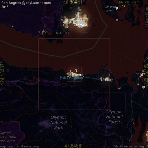
Analysis of Port Angeles night lights 2016
Square area 10x10 km:
 3.13%
3.13%90-99
1.93%80-89
0.3%70-79
2.68%60-69
5.51%50-59
4.91%40-49
3.87%30-39
2.98%20-29
2.68%10-19
16.82%0-9
55.21%Square area 50x50 km:
0.14%90-99
0.14%80-89
0.03%70-79
0.16%60-69
0.34%50-59
0.27%40-49
0.2%30-39
0.16%20-29
0.16%10-19
0.72%0-9
97.66%Clear (daylight) street map image can be seen on geolist.org.
Map coordinates:
48° 35' 7.5" North, 124° 8' 1.9" West
48° 7' 5.3" North, 123° 25' 50.7" West
47° 38' 47.8" North, 122° 43' 39.4" West
Some cities around Port Angeles sort by population:
• Victoria, CA
35.8 km =22.2 mi,  9°
9°
• Oak Harbor
61.5 km =38.2 mi,  71°
71°
• Langford, CA
37.2 km =23.1 mi,  351°
351°
• Oak Bay, CA
38.1 km =23.7 mi, 14°
• Colwood, CA
35.2 km =21.9 mi, 353°
• North Saanich, CA
61 km =37.9 mi,  0°
0°
• Sequim
24.8 km =15.4 mi,  99°
99°
• Sooke, CA
36 km =22.4 mi,  322°
322°
5807212 (p: 19,448)
Sources (retrieved 2019-11-25):
» Earth at Night: Flat Maps 2012, 2016