Seffner night lights from space
Night Light of Seffner (Florida) from space (United States) Src. Average luminocity for 10x10km area is 79.4318% and for 50x50km: 57.0251%.
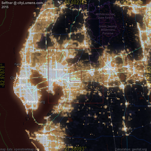
Analysis of Seffner night lights 2016
Square area 10x10 km:
 11.55%
90-99
14.02%80-89
21.4%70-79
21.97%60-69
27.84%50-59
3.22%40-49
0%30-39
0%20-29
0%10-19
0%0-9
0%Square area 50x50 km:
13.71%90-99
10.54%80-89
5.85%70-79
7.7%60-69
16.29%50-59
7.33%40-49
5.94%30-39
4.86%20-29
7.08%10-19
9.4%0-9
11.27%Clear (daylight) street map image can be seen on geolist.org.
Map coordinates:
28° 36' 9.9" North, 82° 58' 43.6" West
27° 59' 1.1" North, 82° 16' 32.3" West
27° 21' 39.3" North, 81° 34' 21.1" West
Some cities around Seffner sort by population:
• Brandon
5.2 km =3.2 mi,  191°
191°
• Valrico
6.4 km =4 mi,  142°
142°
• Temple Terrace
12.5 km =7.8 mi,  297°
297°
• East Lake-Orient Park
10.1 km =6.3 mi,  269°
269°
• Bloomingdale
10.6 km =6.6 mi,  160°
160°
• Palm River-Clair Mel
12.2 km =7.6 mi,  236°
236°
• Thonotosassa
9 km =5.6 mi,  343°
343°
• Mango
3.1 km =1.9 mi,  261°
261°
4172413 (p: 7,579)
Sources (retrieved 2019-11-25):
» Earth at Night: Flat Maps 2012, 2016