Mango night lights from space
Night Light of Mango (Florida) from space (United States) Src. Average luminocity for 10x10km area is 86.9811% and for 50x50km: 58.0236%.
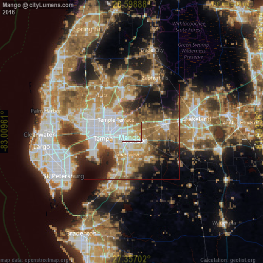
Analysis of Mango night lights 2016
Square area 10x10 km:
 25.76%
90-99
22.92%80-89
18.94%70-79
21.02%60-69
10.61%50-59
0.76%40-49
0%30-39
0%20-29
0%10-19
0%0-9
0%Square area 50x50 km:
14.8%90-99
11.1%80-89
6.03%70-79
7.9%60-69
15.4%50-59
6.96%40-49
5.86%30-39
4.91%20-29
6.92%10-19
8.8%0-9
11.32%Clear (daylight) street map image can be seen on geolist.org.
Map coordinates:
28° 35' 56" North, 83° 0' 34.6" West
27° 58' 47.1" North, 82° 18' 23.3" West
27° 21' 25.3" North, 81° 36' 12.1" West
Some cities around Mango sort by population:
• Brandon
5.1 km =3.2 mi,  156°
156°
• Valrico
8.3 km =5.2 mi,  124°
124°
• Temple Terrace
10.2 km =6.3 mi,  307°
307°
• East Lake-Orient Park
7.1 km =4.4 mi,  272°
272°
• Palm River-Clair Mel
9.5 km =5.9 mi,  229°
229°
• Thonotosassa
9.1 km =5.7 mi,  2°
2°
• Seffner
3.1 km =1.9 mi,  81°
81°
• Progress Village
10.5 km =6.5 mi,  212°
212°
4163318 (p: 11,313)
Sources (retrieved 2019-11-25):
» Earth at Night: Flat Maps 2012, 2016