Valrico night lights from space
Night Light of Valrico (Florida) from space (United States) Src. Average luminocity for 10x10km area is 73.7311% and for 50x50km: 53.2982%.

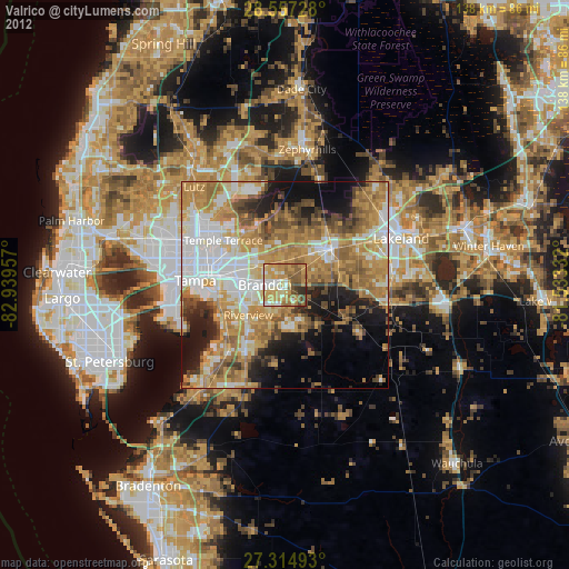
Analysis of Valrico night lights 2016
Square area 10x10 km:
 10.04%
90-99
14.39%80-89
13.64%70-79
16.67%60-69
21.4%50-59
15.53%40-49
6.44%30-39
1.7%20-29
0.19%10-19
0%0-9
0%Square area 50x50 km:
11.11%90-99
9.9%80-89
5.24%70-79
7.57%60-69
16.57%50-59
7.95%40-49
5.31%30-39
4.73%20-29
7.03%10-19
9.05%0-9
15.55%Clear (daylight) street map image can be seen on geolist.org.
Map coordinates:
28° 33' 26.2" North, 82° 56' 22.5" West
27° 56' 16.4" North, 82° 14' 11.2" West
27° 18' 53.7" North, 81° 31' 60" West
Some cities around Valrico sort by population:
• Brandon
4.9 km =3 mi,  269°
269°
• Riverview
11.9 km =7.4 mi,  227°
227°
• Bloomingdale
4.9 km =3 mi,  184°
184°
• Fish Hawk
10 km =6.2 mi,  165°
165°
• Mango
8.3 km =5.2 mi,  304°
304°
• Seffner
6.4 km =4 mi,  322°
322°
• Boyette
13.5 km =8.4 mi, 174°
• Progress Village
13.3 km =8.3 mi,  251°
251°
4176318 (p: 35,545)
Sources (retrieved 2019-11-25):
» Earth at Night: Flat Maps 2012, 2016