Temple Terrace night lights from space
Night Light of Temple Terrace (Florida) from space (United States) Src. Average luminocity for 10x10km area is 94.4451% and for 50x50km: 65.1492%.

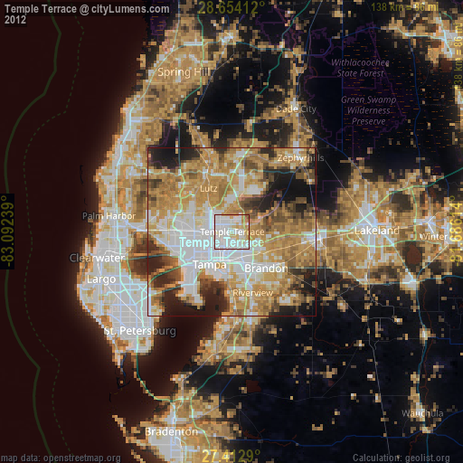
Analysis of Temple Terrace night lights 2016
Square area 10x10 km:
 52.08%
90-99
28.41%80-89
6.63%70-79
8.14%60-69
4.55%50-59
0.19%40-49
0%30-39
0%20-29
0%10-19
0%0-9
0%Square area 50x50 km:
15.74%90-99
12.13%80-89
7.16%70-79
9.46%60-69
19.03%50-59
7.48%40-49
6.93%30-39
5.71%20-29
8.67%10-19
6.03%0-9
1.66%Clear (daylight) street map image can be seen on geolist.org.
Map coordinates:
28° 39' 14.8" North, 83° 5' 32.6" West
28° 2' 7.1" North, 82° 23' 21.3" West
27° 24' 46.4" North, 81° 41' 10.1" West
Some cities around Temple Terrace sort by population:
• Tampa
11.9 km =7.4 mi,  214°
214°
• University
6.5 km =4 mi,  311°
311°
• Egypt Lake-Leto
11.6 km =7.2 mi,  260°
260°
• Carrollwood
10.3 km =6.4 mi,  279°
279°
• Lake Magdalene
9.2 km =5.7 mi,  298°
298°
• East Lake-Orient Park
5.9 km =3.7 mi,  170°
170°
• Thonotosassa
9 km =5.6 mi,  71°
71°
• Mango
10.2 km =6.3 mi,  127°
127°
4174969 (p: 25,731)
Sources (retrieved 2019-11-25):
» Earth at Night: Flat Maps 2012, 2016