Sealy night lights from space
Night Light of Sealy (Texas) from space (United States) Src. Average luminocity for 10x10km area is 28.0734% and for 50x50km: 5.4241%.
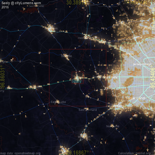
Analysis of Sealy night lights 2016
Square area 10x10 km:
 1.59%
1.59%90-99
2.58%80-89
2.98%70-79
2.38%60-69
7.14%50-59
3.97%40-49
8.93%30-39
4.17%20-29
7.14%10-19
31.75%0-9
27.38%Square area 50x50 km:
0.12%90-99
0.23%80-89
0.72%70-79
0.68%60-69
1.02%50-59
0.9%40-49
0.92%30-39
1.49%20-29
1.78%10-19
4.22%0-9
87.91%Clear (daylight) street map image can be seen on geolist.org.
Map coordinates:
30° 23' 21.1" North, 96° 51' 37.1" West
29° 46' 50.8" North, 96° 9' 25.8" West
29° 10' 7.2" North, 95° 27' 14.6" West
Some cities around Sealy sort by population:
• Rosenberg
41.9 km =26 mi,  126°
126°
• Cinco Ranch
38.8 km =24.1 mi,  96°
96°
• Katy
32.1 km =19.9 mi,  89°
89°
• Richmond
44.2 km =27.5 mi,  119°
119°
• Hempstead
36 km =22.4 mi,  12°
12°
• Prairie View
38.4 km =23.9 mi,  25°
25°
• Fulshear
26.8 km =16.7 mi,  112°
112°
• Brookshire
19.9 km =12.4 mi, 88°
4727629 (p: 6,403)
Sources (retrieved 2019-11-25):
» Earth at Night: Flat Maps 2012, 2016