Brookshire night lights from space
Night Light of Brookshire (Texas) from space (United States) Src. Average luminocity for 10x10km area is 28.9028% and for 50x50km: 28.1299%.
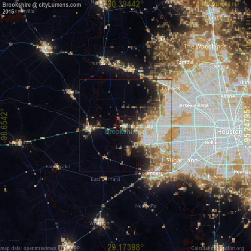
Analysis of Brookshire night lights 2016
Square area 10x10 km:
 0.99%
0.99%90-99
2.58%80-89
4.56%70-79
3.17%60-69
3.97%50-59
3.37%40-49
4.17%30-39
11.51%20-29
12.5%10-19
33.33%0-9
19.84%Square area 50x50 km:
5.58%90-99
5.86%80-89
4.42%70-79
4.27%60-69
4.38%50-59
3.12%40-49
3.17%30-39
3.3%20-29
3.9%10-19
7.47%0-9
54.53%Clear (daylight) street map image can be seen on geolist.org.
Map coordinates:
30° 23' 39.9" North, 96° 39' 15.1" West
29° 47' 9.8" North, 95° 57' 3.9" West
29° 10' 26.3" North, 95° 14' 52.6" West
Some cities around Brookshire sort by population:
• Mission Bend
29.5 km =18.3 mi,  110°
110°
• Rosenberg
28.9 km =18 mi,  151°
151°
• Cinco Ranch
19.4 km =12.1 mi, 105°
• Katy
12.2 km =7.6 mi,  90°
90°
• Pecan Grove
27.7 km =17.2 mi,  130°
130°
• Richmond
29.2 km =18.1 mi,  140°
140°
• Sealy
19.9 km =12.4 mi,  268°
268°
• Fulshear
11.8 km =7.3 mi,  155°
155°
4676571 (p: 5,120)
Sources (retrieved 2019-11-25):
» Earth at Night: Flat Maps 2012, 2016