Richmond night lights from space
Night Light of Richmond (Texas) from space (United States) Src. Average luminocity for 10x10km area is 75.928% and for 50x50km: 44.5652%.
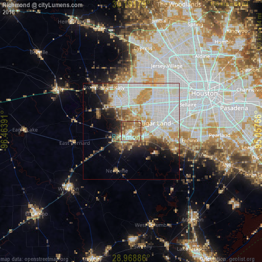
Analysis of Richmond night lights 2016
Square area 10x10 km:
 12.31%
90-99
15.91%80-89
12.69%70-79
15.91%60-69
26.14%50-59
13.07%40-49
3.98%30-39
0%20-29
0%10-19
0%0-9
0%Square area 50x50 km:
15.05%90-99
11.21%80-89
5.82%70-79
5.65%60-69
4.52%50-59
3.49%40-49
2.76%30-39
2.53%20-29
3.88%10-19
6.74%0-9
38.35%Clear (daylight) street map image can be seen on geolist.org.
Map coordinates:
30° 11' 30.4" North, 96° 27' 50.1" West
29° 34' 55.8" North, 95° 45' 38.8" West
28° 58' 7.9" North, 95° 3' 27.6" West
Some cities around Richmond sort by population:
• Sugar Land
12.9 km =8 mi,  71°
71°
• Mission Bend
15.5 km =9.6 mi,  36°
36°
• Rosenberg
5.4 km =3.4 mi,  238°
238°
• Cinco Ranch
17.4 km =10.8 mi,  0°
0°
• Pecan Grove
5.6 km =3.5 mi,  30°
30°
• New Territory
7.8 km =4.8 mi,  80°
80°
• Four Corners
13.8 km =8.6 mi,  46°
46°
• Greatwood
8.8 km =5.5 mi,  110°
110°
4722684 (p: 12,138)
Sources (retrieved 2019-11-25):
» Earth at Night: Flat Maps 2012, 2016