Santa Fe night lights from space
Night Light of Santa Fe (Texas) from space (United States) Src. Average luminocity for 10x10km area is 51.3712% and for 50x50km: 36.6513%.
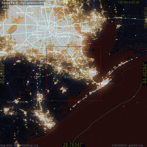
Analysis of Santa Fe night lights 2016
Square area 10x10 km:
 0.76%
0.76%90-99
0.76%80-89
9.85%70-79
9.85%60-69
11.93%50-59
21.4%40-49
20.83%30-39
10.04%20-29
3.6%10-19
9.66%0-9
1.33%Square area 50x50 km:
4.69%90-99
5.35%80-89
6.24%70-79
7.96%60-69
6.67%50-59
6.76%40-49
5.56%30-39
5.18%20-29
5.33%10-19
8.24%0-9
38.03%Clear (daylight) street map image can be seen on geolist.org.
Map coordinates:
29° 59' 19.9" North, 95° 48' 32" West
29° 22' 40.8" North, 95° 6' 20.7" West
28° 45' 48.5" North, 94° 24' 9.5" West
Some cities around Santa Fe sort by population:
• League City
14.4 km =8.9 mi,  4°
4°
• Friendswood
19.2 km =11.9 mi,  331°
331°
• Alvin
14.3 km =8.9 mi,  290°
290°
• Dickinson
10.6 km =6.6 mi,  29°
29°
• La Marque
13.1 km =8.1 mi,  94°
94°
• Webster
17.8 km =11.1 mi,  356°
356°
• Bacliff
18.1 km =11.2 mi,  37°
37°
• Hitchcock
9.3 km =5.8 mi,  110°
110°
4727022 (p: 13,037)
Sources (retrieved 2019-11-25):
» Earth at Night: Flat Maps 2012, 2016