La Marque night lights from space
Night Light of La Marque (Texas) from space (United States) Src. Average luminocity for 10x10km area is 75.6686% and for 50x50km: 30.3565%.
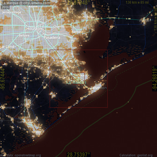
Analysis of La Marque night lights 2016
Square area 10x10 km:
 14.77%
90-99
13.64%80-89
20.08%70-79
18.56%60-69
10.23%50-59
12.88%40-49
4.36%30-39
2.46%20-29
3.03%10-19
0%0-9
0%Square area 50x50 km:
4.26%90-99
4.38%80-89
5.14%70-79
6.06%60-69
4.85%50-59
5.11%40-49
4.59%30-39
4.48%20-29
5.61%10-19
9.12%0-9
46.39%Clear (daylight) street map image can be seen on geolist.org.
Map coordinates:
29° 58' 46.1" North, 95° 40' 28" West
29° 22' 6.9" North, 94° 58' 16.7" West
28° 45' 14.3" North, 94° 16' 5.5" West
Some cities around La Marque sort by population:
• League City
19.5 km =12.1 mi,  322°
322°
• Galveston
18.4 km =11.4 mi,  113°
113°
• Texas City
6.9 km =4.3 mi,  75°
75°
• Dickinson
12.9 km =8 mi, 322°
• Seabrook
22.4 km =13.9 mi,  346°
346°
• Santa Fe
13.1 km =8.1 mi,  274°
274°
• Bacliff
15.5 km =9.6 mi, 352°
• Hitchcock
4.9 km =3 mi,  242°
242°
4704027 (p: 15,908)
Sources (retrieved 2019-11-25):
» Earth at Night: Flat Maps 2012, 2016