Sandston night lights from space
Night Light of Sandston (Virginia) from space (United States) Src. Average luminocity for 10x10km area is 62.5682% and for 50x50km: 35.9696%.
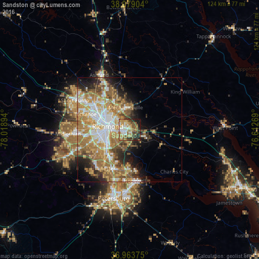
Analysis of Sandston night lights 2016
Square area 10x10 km:
 8.77%
8.77%90-99
12.99%80-89
9.25%70-79
15.58%60-69
8.44%50-59
12.66%40-49
9.09%30-39
7.79%20-29
9.09%10-19
6.33%0-9
0%Square area 50x50 km:
6.78%90-99
6.3%80-89
4.71%70-79
7.01%60-69
8.05%50-59
5.94%40-49
3.53%30-39
3.7%20-29
4.97%10-19
6.67%0-9
42.34%Clear (daylight) street map image can be seen on geolist.org.
Map coordinates:
38° 4' 44.5" North, 78° 1' 8.2" West
37° 31' 24.5" North, 77° 18' 56.9" West
36° 57' 49.5" North, 76° 36' 45.7" West
Some cities around Sandston sort by population:
• Richmond
13.2 km =8.2 mi,  284°
284°
• Mechanicsville
10.8 km =6.7 mi,  331°
331°
• Highland Springs
2.7 km =1.7 mi,  337°
337°
• East Highland Park
10.3 km =6.4 mi,  308°
308°
• Montrose
5.5 km =3.4 mi,  266°
266°
• Fort Lee
3.5 km =2.2 mi,  209°
209°
• Bensley
14.1 km =8.8 mi,  232°
232°
• Chamberlayne
15.2 km =9.4 mi,  319°
319°
4784352 (p: 7,571)
Sources (retrieved 2019-11-25):
» Earth at Night: Flat Maps 2012, 2016