Highland Springs night lights from space
Night Light of Highland Springs (Virginia) from space (United States) Src. Average luminocity for 10x10km area is 63.4286% and for 50x50km: 35.8512%.
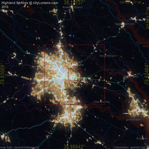
Analysis of Highland Springs night lights 2016
Square area 10x10 km:
 9.25%
9.25%90-99
14.61%80-89
8.12%70-79
16.07%60-69
7.95%50-59
12.01%40-49
10.06%30-39
6.82%20-29
7.79%10-19
6.98%0-9
0.32%Square area 50x50 km:
6.68%90-99
6.32%80-89
4.61%70-79
7%60-69
8.23%50-59
5.85%40-49
3.5%30-39
3.73%20-29
4.9%10-19
6.59%0-9
42.59%Clear (daylight) street map image can be seen on geolist.org.
Map coordinates:
38° 6' 4.9" North, 78° 1' 51.2" West
37° 32' 45.5" North, 77° 19' 39.9" West
36° 59' 11.1" North, 76° 37' 28.7" West
Some cities around Highland Springs sort by population:
• Richmond
11.7 km =7.3 mi,  274°
274°
• Mechanicsville
8.1 km =5 mi,  330°
330°
• East Highland Park
8 km =5 mi,  299°
299°
• Lakeside
14.8 km =9.2 mi, 297°
• Montrose
5.3 km =3.3 mi,  237°
237°
• Sandston
2.7 km =1.7 mi,  157°
157°
• Fort Lee
5.6 km =3.5 mi,  186°
186°
• Chamberlayne
12.6 km =7.8 mi,  315°
315°
4764127 (p: 15,711)
Sources (retrieved 2019-11-25):
» Earth at Night: Flat Maps 2012, 2016