East Highland Park night lights from space
Night Light of East Highland Park (Virginia) from space (United States) Src. Average luminocity for 10x10km area is 84.2976% and for 50x50km: 39.869%.
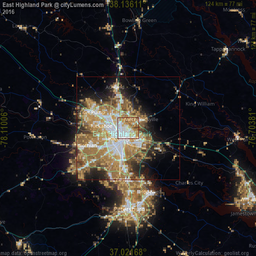
Analysis of East Highland Park night lights 2016
Square area 10x10 km:
 29.59%
90-99
20.24%80-89
11.73%70-79
15.31%60-69
13.61%50-59
7.31%40-49
2.21%30-39
0%20-29
0%10-19
0%0-9
0%Square area 50x50 km:
7.07%90-99
6.71%80-89
5.24%70-79
7.6%60-69
9.32%50-59
7.28%40-49
4.11%30-39
4.31%20-29
5.62%10-19
7.63%0-9
35.11%Clear (daylight) street map image can be seen on geolist.org.
Map coordinates:
38° 8' 10" North, 78° 6' 36.2" West
37° 34' 51.5" North, 77° 24' 24.9" West
37° 1' 18" North, 76° 42' 13.7" West
Some cities around East Highland Park sort by population:
• Richmond
5.6 km =3.5 mi,  237°
237°
• Mechanicsville
4.3 km =2.7 mi,  43°
43°
• Highland Springs
8 km =5 mi,  119°
119°
• Lakeside
6.8 km =4.2 mi,  295°
295°
• Montrose
7.2 km =4.5 mi,  159°
159°
• Dumbarton
7.9 km =4.9 mi,  288°
288°
• Sandston
10.3 km =6.4 mi,  128°
128°
• Chamberlayne
5.4 km =3.4 mi,  339°
339°
4756972 (p: 14,796)
Sources (retrieved 2019-11-25):
» Earth at Night: Flat Maps 2012, 2016