Mechanicsville night lights from space
Night Light of Mechanicsville (Virginia) from space (United States) Src. Average luminocity for 10x10km area is 68.7092% and for 50x50km: 36.0713%.
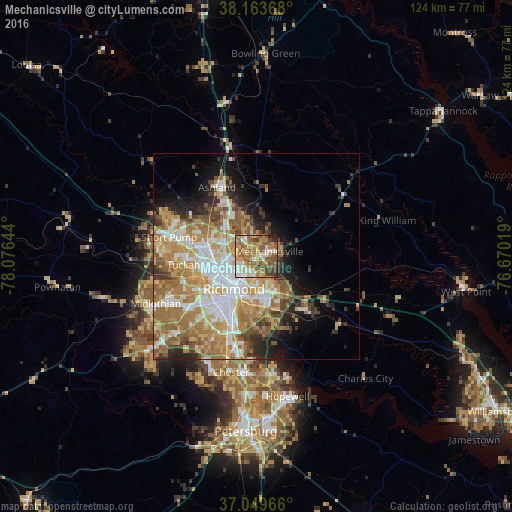

Analysis of Mechanicsville night lights 2016
Square area 10x10 km:
 8.67%
8.67%90-99
11.39%80-89
10.37%70-79
13.44%60-69
21.94%50-59
18.54%40-49
9.18%30-39
4.59%20-29
1.7%10-19
0.17%0-9
0%Square area 50x50 km:
6.8%90-99
6.45%80-89
4.67%70-79
6.95%60-69
8.33%50-59
6.08%40-49
3.46%30-39
3.51%20-29
4.32%10-19
6.36%0-9
43.09%Clear (daylight) street map image can be seen on geolist.org.
Map coordinates:
38° 9' 49.2" North, 78° 4' 35.2" West
37° 36' 31.5" North, 77° 22' 23.9" West
37° 2' 58.8" North, 76° 40' 12.7" West
Some cities around Mechanicsville sort by population:
• Richmond
9.8 km =6.1 mi,  231°
231°
• Highland Springs
8.1 km =5 mi,  150°
150°
• East Highland Park
4.3 km =2.7 mi,  223°
223°
• Lakeside
9.1 km =5.7 mi,  269°
269°
• Montrose
9.8 km =6.1 mi,  182°
182°
• Dumbarton
10.4 km =6.5 mi, 266°
• Sandston
10.8 km =6.7 mi, 151°
• Chamberlayne
5.3 km =3.3 mi,  292°
292°
4772566 (p: 36,348)
Sources (retrieved 2019-11-25):
» Earth at Night: Flat Maps 2012, 2016