Montrose night lights from space
Night Light of Montrose (Virginia) from space (United States) Src. Average luminocity for 10x10km area is 84.2078% and for 50x50km: 41.5183%.
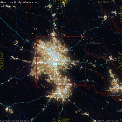
Analysis of Montrose night lights 2016
Square area 10x10 km:
 25.49%
90-99
19.97%80-89
14.61%70-79
22.56%60-69
11.85%50-59
4.22%40-49
0.65%30-39
0.65%20-29
0%10-19
0%0-9
0%Square area 50x50 km:
7.37%90-99
6.97%80-89
5.46%70-79
8.1%60-69
9.82%50-59
7.74%40-49
4.02%30-39
4.38%20-29
5.58%10-19
7.53%0-9
33.03%Clear (daylight) street map image can be seen on geolist.org.
Map coordinates:
38° 4' 34.6" North, 78° 4' 53.2" West
37° 31' 14.5" North, 77° 22' 41.9" West
36° 57' 39.4" North, 76° 40' 30.7" West
Some cities around Montrose sort by population:
• Richmond
8.1 km =5 mi,  296°
296°
• Mechanicsville
9.8 km =6.1 mi,  2°
2°
• Meadowbrook
11.6 km =7.2 mi,  226°
226°
• Highland Springs
5.3 km =3.3 mi,  57°
57°
• East Highland Park
7.2 km =4.5 mi,  339°
339°
• Sandston
5.5 km =3.4 mi,  86°
86°
• Fort Lee
4.7 km =2.9 mi,  126°
126°
• Bensley
10 km =6.2 mi,  214°
214°
4773747 (p: 7,993)
Sources (retrieved 2019-11-25):
» Earth at Night: Flat Maps 2012, 2016