Saltillo night lights from space
Night Light of Saltillo (Mississippi) from space (United States) Src. Average luminocity for 10x10km area is 31.7601% and for 50x50km: 15.3426%.
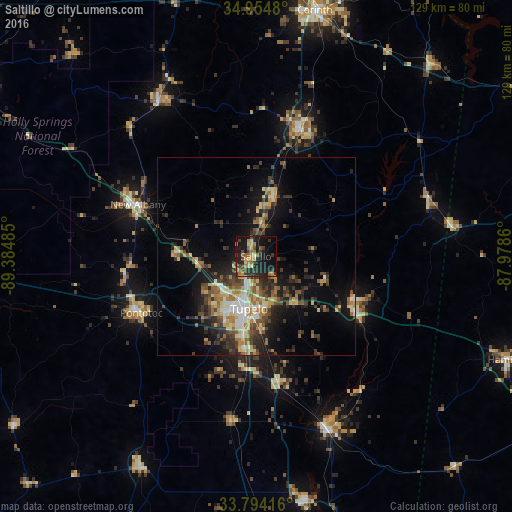
Analysis of Saltillo night lights 2016
Square area 10x10 km:
 0%
0%90-99
1.65%80-89
4.95%70-79
5.49%60-69
8.24%50-59
2.93%40-49
7.14%30-39
8.61%20-29
13.19%10-19
34.43%0-9
13.37%Square area 50x50 km:
1.31%90-99
1.75%80-89
2.31%70-79
1.78%60-69
2.66%50-59
2.28%40-49
2.64%30-39
3.7%20-29
4.35%10-19
9.92%0-9
67.3%Clear (daylight) street map image can be seen on geolist.org.
Map coordinates:
34° 57' 17.3" North, 89° 23' 5.5" West
34° 22' 35.4" North, 88° 40' 54.2" West
33° 47' 39" North, 87° 58' 43" West
Some cities around Saltillo sort by population:
• Tupelo
13.3 km =8.3 mi,  189°
189°
• Corinth
63.7 km =39.6 mi,  13°
13°
• New Albany
32.6 km =20.3 mi,  293°
293°
• Booneville
33 km =20.5 mi,  18°
18°
• Amory
47.1 km =29.3 mi,  157°
157°
• Pontotoc
32.4 km =20.1 mi,  243°
243°
• Aberdeen
62.6 km =38.9 mi,  168°
168°
• Ripley
46.4 km =28.8 mi,  327°
327°
4444938 (p: 5,004)
Sources (retrieved 2019-11-25):
» Earth at Night: Flat Maps 2012, 2016