Amory night lights from space
Night Light of Amory (Mississippi) from space (United States) Src. Average luminocity for 10x10km area is 30.0507% and for 50x50km: 7.0704%.
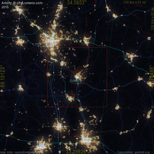
Analysis of Amory night lights 2016
Square area 10x10 km:
 3.32%
3.32%90-99
3.85%80-89
2.62%70-79
6.99%60-69
5.94%50-59
2.27%40-49
3.32%30-39
7.34%20-29
1.92%10-19
32.87%0-9
29.55%Square area 50x50 km:
0.31%90-99
0.59%80-89
1.23%70-79
0.74%60-69
0.93%50-59
0.8%40-49
1.2%30-39
2.1%20-29
1.96%10-19
6.03%0-9
84.1%Clear (daylight) street map image can be seen on geolist.org.
Map coordinates:
34° 33' 55.1" North, 89° 11' 28.4" West
33° 59' 3.4" North, 88° 29' 17.2" West
33° 23' 57.3" North, 87° 47' 5.9" West
Some cities around Amory sort by population:
• Tupelo
36.4 km =22.6 mi,  326°
326°
• Starkville
66.8 km =41.5 mi,  207°
207°
• Columbus
54.6 km =33.9 mi,  174°
174°
• West Point
44.5 km =27.7 mi,  199°
199°
• Hamilton
49.2 km =30.6 mi,  69°
69°
• Pontotoc
55.4 km =34.4 mi,  301°
301°
• Aberdeen
18.4 km =11.4 mi, 196°
• Saltillo
47.1 km =29.3 mi,  337°
337°
4416192 (p: 7,067)
Sources (retrieved 2019-11-25):
» Earth at Night: Flat Maps 2012, 2016