Pontotoc night lights from space
Night Light of Pontotoc (Mississippi) from space (United States) Src. Average luminocity for 10x10km area is 32.6923% and for 50x50km: 8.8577%.
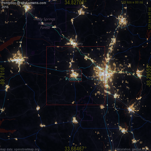
Analysis of Pontotoc night lights 2016
Square area 10x10 km:
 2.01%
2.01%90-99
4.03%80-89
8.06%70-79
7.14%60-69
6.59%50-59
2.93%40-49
1.83%30-39
4.58%20-29
2.93%10-19
31.5%0-9
28.39%Square area 50x50 km:
0.61%90-99
0.98%80-89
1.21%70-79
1.13%60-69
1.47%50-59
1.09%40-49
1.29%30-39
2.34%20-29
2.37%10-19
7.23%0-9
80.27%Clear (daylight) street map image can be seen on geolist.org.
Map coordinates:
34° 49' 37.5" North, 89° 42' 6.5" West
34° 14' 52.4" North, 88° 59' 55.2" West
33° 39' 52.8" North, 88° 17' 44" West
Some cities around Pontotoc sort by population:
• Tupelo
27 km =16.8 mi,  87°
87°
• Oxford
49.6 km =30.8 mi,  285°
285°
• New Albany
27.4 km =17 mi,  358°
358°
• Booneville
60.4 km =37.5 mi,  40°
40°
• Amory
55.4 km =34.4 mi,  121°
121°
• Aberdeen
63 km =39.1 mi,  138°
138°
• Ripley
53.8 km =33.4 mi,  4°
4°
• Saltillo
32.4 km =20.1 mi,  63°
63°
4442067 (p: 5,944)
Sources (retrieved 2019-11-25):
» Earth at Night: Flat Maps 2012, 2016